فرسايش توده اي

فرسايش توده­اي


اين نوع فرسايش در روي زمين اغلب به شكل عوارض زمين كه معرف حركات خاك در گذشته است ظاهر مي­گردد. اين حركات عبارتست از تورم و بالا آمدن خاك، سرخوردگي، خزيدن زمين و ريزش خاك (حركت يخچالها).

در فرسايش توده­اي قسمتي از خاك دامنه كوهها به حركت در مي­آيد كه يا ممكن است بر اثر اشباع شدن خاك طبقه رويي از آب و نفوذپذيري خاك طبقه زيري، خاك رويي به حركت در آيد، يا ممكن است بر اثر لغزش اين عمل اتفاق افتد، به اين معني كه توده­اي از كوه از محل اوليه خود جدا مي­شود و در محل ديگري قرار مي­گيرد، يا ممكن است در نتيجه ريزش باشد كه در اين حالت قسمتي از كوه ريزش مي­كند و در سطح­هاي پايين­تر روي هم انباشته مي­شود.

Mass Movement

Mass Movement

Mass movement  is the down slope movement of earth materials under the influence of gravity. The detachment and movement of earth materials occurs if the stress imposed is greater than the strength of the material to hold it in place. Shear strength is a measure if the resistance of earth materials to be moved. The interlocking of soil particles increases the ability of material to stay in place. Plant roots also help bind soil particles together. Shear stress is primarily a function of the force exerted by the weight of the material under the influence of gravity acting in the down slope direction. The slope of the surface determines the amount of stress that occurs on earth materials. Water destabilizes hill slopes by creating pressure in the pore spaces of earth materials. Water infiltrating into slope materials saturates the soil particles at depth by filling the pore spaces between. The weight of water lying above creates water pressure that drives soil particles apart. This lessens the friction between them and enables them to slip past one another. Material is mobilized when the shear stress imposed on a surface exceeds the shear strength. The movement, especially in the case of slides and slumps, is along a failure plane. The failure plane may be a well-defined layer of clay or rock upon which sets the destabilized surface material. Humans induce mass movement when subjecting a slope to a load that exceeds its ability to resist movement. People building houses on scenic hill slopes often find their homes threatened by a landslide. Undercutting of hillsides during road construction commonly creates unstable slopes making them prone to failure.

Types of mass movement

Soil creep is nearly imperceptible to the naked eye as it is the slowest of all types of mass movement. Soil creep generally occurs in the top few meters of the surface and is accomplished by expansion and contraction of the soil. For instance, when water in the soil freezes the ice pushes soil particles outward perpendicular to the slope. Upon warming, the ice melts and the soil is pulled down slope under the influence of gravity. Over many freeze-thaw cycles soil moves slowly down slope. In many cases one might not be able to tell that soil creep is occurring by just examining the surface. However, trees growing on surfaces undergoing creep will have curved trunks or roots that are curved. Broken retaining walls and curved railroad tracks also indicate creep in action.La Conchita, CA Landslide

Figure WM.5  La Conchita, CA 1995 landslide  (Courtesy USGS)

A slide is a sheet of material that slips over a failure plane ending anywhere from a meter to a kilometer down slope. Slides produce concave scars while slumps tend to produce a scarp or cliff exposure. Trees are broken and bent and the slide can bury the soil down slope. Digging into buried soils and analyzing their contents can tell us about the age and what the environment was like when the slide occurred.  Note the concave scar typically produced by a slide.

La Conchita, California has experienced devastating landslides in recent years. Unstable slopes mobilized by rain water caused a landslide and debris flow seen in Figure WM.5. The city lies on a narrow strip of coast 250m (800ft) wide between the shoreline and a 180 m (600ft) bluff above it. Extraordinary rains and rising groundwater levels caused the slope to fail, fortunately no one was killed. However, in 2005, another year of abnormally high rain fall caused the slope to fail again, this time burying structures and killing 10 people.

Figure WM.6  Slump on hill side. 

Notice the step-like appearance of terracettes (Courtesy USGS DDS21 )

(Click image to enlarge)

Slumps are characterized by a backward rotation of the earth material as it moves along a curved failure plane resulting in a reverse slope.  Slumps take place as an intermittent movement of earth or rock material, often as several independent units, creating a number of step-like "terracettes." Undercutting of slopes by stream erosion, waves, and road building are common causes of slumping.

Figure WM.7 Solifluction terraces, Niwot Ridge, Colorado

Solifluction is the down slope movement of soil over a permanently frozen subsurface. Solifluction is common on slopes underlain by permafrost. During the summer when the upper permafrost is activated, the waterlogged soil mass slowly moves down slope to form solifluction lobes or terraces.

A flow is the down slope movement of water-saturated soil, regolith, weak shale, or weak clay layers. Earth flows are fairly slow, occurring  over a few hours or so slow that they are almost imperceptible. Earth flows are accompanied with slumping, but unlike slumping, there is no backward rotation. Earth flows differ from mudflows in that they (1) tend to be slower, (2) are not confined to channels, (3) are more common in humid areas than dry, and (4) have a lower water content.

Figure WM.8 Mudflow, Pacific Palisades, CA.
(Courtesy USGS DDS21 )
Click image to enlarge

A mudflow is the rapid down slope movement of water-saturated water- saturated soil, regolith. The higher water content creates a flow rapid enough to be perceptible to the eye. Conditions favorable for the development of mudflows are: (1) unconsolidated surface materials, (2) steep slopes abundant but intermittent precipitation, and (3) sparse cover of vegetation. Mudflows tend to be more prevalent in dry regions where vegetation is sparse and heavy rains may form. When set in motion, they occupy stream-cut channels rushing along in a torrential flow of mud.  

Figure WM.9 Talus slope, Isabelle Valley, Colorado 

Rock fall is one of the most sudden forms of mass movement. Rock fall occurs when blocks of rock shed from a cliff face and collect at the base. Talus is a term that is applied to an accumulation of rock by rock fall. 


حرکت های توده ای در سیاره ونوس


Mass Movements on Venus :Preliminary Results from

Magellan Cycle I Observations


Michael C. Malin, Malin Space Science Systems, P. O. Box 910148, San Diego, CA 92191-0148


Abstract

Introduction

Observations and Descriptions of Venusian Mass Movement Features

Rock Slumps and Rock/Block Slides

Rock/Block Slide-Avalanches

Rock/Debris Avalanches

Debris Avalanches and Flows (?)

Statistical Relationships of Height and Length

Discussion

Passive Factors that Favor Mass Movements


Topography

Lithology and Environment

Stratigraphy and Structure

Active Factors that Initiate Mass Movements

Time Relationships of Mass Movements

Conclusions

Acknowledgements

References

ادامه نوشته

حرکت های توده ای . زمین لغزش

حرکت های توده ای :

به گسیختگی مواد تشکیل دهنده دامنه های پر شیب بر اثر عوامل آبگیری

و کاهش نیروی اصطکاک و افزایش نیروی ثقل حرکت های توده ای اطلاق

میگردد .

عوامل موثر در حرکات توده ای به نظر دونالد:

۱: نوع سازند (اصلیترین عامل). سازند هایی مانند مارن شیل و یا تناوبی

 از این دو  مستعد حرکات توده ای میباشند.هر چه رس های غیر اشباع

 مانند مونت موریلونیت و  ایلیت زیادتر باشد سازند حساستر به حرکات

توده ای میباشد.همچنین هر چه نمک های  کلرور سدیم زیادتر  باشد سازند

 حساس تر به فرسایش است.

۲: میزان رطوبت:در اقلیم های مرطوب و نیمه مرطوب و دامنه های رو به

 شمال و بارش  های برفی متوالی همچنین دوره های خشکسالی و رطوبت

میتواند در تشدید حرکات توده ای  نقش  داشته باشد.

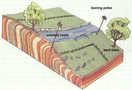
۳: وضعیت تکتونیک (توپوگرافی ): شیب دامنه (شیب های بالای ۳۰

 در صد) و شیب و جهت  لایه ها گسل و شکست ها میتواند در تشکیل و

 تشدید حرکات توده ای نقش داشته  باشد.

۴: نوع استفاده از زمین

انواع حرکات توده ای : تقسیم بندی های متعددی وجود دارد. مهمترین

آنها تقسیم بندی  شارپ ,دونالد و طبقه بندی ایرانی (!!!!!) میباشد.

طبقه بندی شارپ: شارپ حرکات توده ای را به دو دسته تقسیم کرد:

۱):جریان ها : در محیط مرطوب : مانند رانش زمین (Earth flow) سولیفلوکسیون.

   روانه گل (Mud flow) . زمین لیزه (Slumping) . در این دسته از حرکات

تود ه ای سرعت   از  بالا به پایین کم میشود. و عامل اصلی آن کاهش اصطکاک داخلی است.

۲):لغزش ها و ریزش ها :در محیط خشک .شامل ریزش (Falling).خزش

(Creeping).

لغزش(Landslide) .ژلیفراکسیون(Gelifraction). در این دسته سر عت حرکت

مواد از بالا به پایین یکسان میباشد.

ویژگی های لغزش ها :

1):معمولا در توده های خاک و یا سنگی مقاوم رویی که دارای زیر بستر

سست (مارنی) باشند اتفاق میافتند.

۲):خط گسستگی (Timberline) به صورت خط طولی میباشد.

۳):محدوده آن رو ی دامنه وسیع است.

۴): بخشی از دامنه به صورت پله ای پایین میاید.

۵)به دیواره ایجاد شده اسکارپ(Scarp) میگویند.

۶): معمولا در اثر گسل یا بریدگی پای دامنه در اثر جاده سازی و یا عبور

 رودخانه و آبراهه از پای دامنه و شسته شدن پای دیواره تشدید میگردد.

۷): شاخص روانی در لایه زیرین بیش از سایر نقاط است.

منبع :جزوه ژئومورفولوژی دکتر اختصاصی( دانشگاه یزد)


                               زمین لغزش های ثانویه

زمین لغزش های بزرگ (مرکب) معمولا شامل زمین لغزش های کوچکتری

هستند که به آنها  زمین لغزش های ثانویه گفته میشود. این زمین لغزش ها از

 چندین جهت با زمین لغزش های  مرکب متفاوتند:

  • حجم کمتری دارند .
  • از طریق نفوذ آب به لایه های زیرین به به سرعت اشباع میگردند.
  • به نیروی کمتری برای آغاز حرکت نیاز دارند.
  • بیشتر از زمین لغزش های بزرگ اتفاق میافتند (فراوانی حرکت بیشتری

    دارند).

  • نیروی عامل حرکت در این نوع زمین لغزش ها میتواند مستقل از زمین
  • لغزش اصلی و دیگر زمین لغزش های ثانویه اطراف آن باشد.

 منابع آب تحت کنترل بشر مانند سیستم های آبیاری و فاضلاب به میزان

زیادی  بر اشباع شدن لایه زیرین زمین لغزش های ثانویه تاثیر میگذارد.شکل

 و جهت زمین لغزش های ثانویه معمولا توسط وضعیت آب زیرزمینی ـ مکان مورد

نظر ـمورفولوژی سطحی ـ خصوصیات مواد تشکیل دهنده سنگ بستر و وجود

 ـ تراکم و جهت درز های ساختمانی در زمین لغزش اصلی  تعیین میگردد.

افزایش درجه شیب در زمین لغزش های اصلی اغلب منجر به توسعه

 زمین  لغزش های ثانویه و جریانات واریزه ای سطحی میگردد.حرکت و

 جابه جایی زمین لغزش اصلی ممکن است منجر به گسترش سطح شکست

گردد که این امر باعث تشکیل زمین لغزشهای ثانویه بیشتری میشود.به طور

 کلی خطرات زمین لغزش های ثانویه بیش از زمین لغزش اصلی میباشد.

وجود آب زیرزمینی باعث گسترش درز ها و انحلال سیمان ـ فرسایش مکانیکی

(از طریق فرسایش لانه ای ) میگردد.که تمامی این عوامل منجر به رشد سریع

 سطوح شکست در طول جابه جایی زمین لغزش های اولیه و ثانویه میگردد.

به هنگام آنالیز هیدرولوژیکی این زمین لغزش ها نباید آناه را به عنوان یک واحد

یکنواخت و همگن به حساب آورد.زیرا این نوع زمین لغزش ها دارای خصوصیات

 متفاوت هیدرولوژیکی میباشند.

منبع:            Landslides_landslide mitigation  

              Reviews in engineering geology 1992                      

نقل از وبلاگ آبخیزداری

خزش و سولیفلوسیون

خزش و سولیفلوسیون

خزش: جریان آهسته خاک یا سنگ  میباشدکه در طول سطح لغزشی

 حرکت نمیکند و جابه جایی آن در جهت عمودی است.خزش تنها بر روی لایه

سطحی زمین وجود دارد.

میزان خزش بستگی به بزرگی و مدت زمان فعالیت تنش اعمال شده بر لایه

 سطحی دارد.

خزش ها به سه دسته تقسیم میگردند:

۱): خزش اولیه: در این خزش ، میزان تنش پس از  مدتی از مقدار زیاد

به مقدار ثابتی نزول  می یابد.

۲):خزش ثانویه:در این نوع خزش ، میزان تنش پس از مدتی ازیک مقدار 

 ثابت به مقداری دیگر افزایش میابد.

۳):خزش ثالث:در این نوع خزش ، مقدار تنش از حد ثابتی به حد نهایت خود افزایش

 میابد و نشست (Collapse) اتفاق میافتد.

خزش ها بر اساس نوع مواد خزش یافته به خزش های خاکی، واریزه ای و

سنگی تقسیم میگردند و در اقالیم معتدله و گرمسیری روی میدهند.

 هوازدگی،یخزدگی،تغییرات دما،جذب آب میتوانند شرایط خزش را مهیا سازند.

گاهی کج شدن پایه های خطوط انتقال برق یا تنه درختان و... بر روی شیبها

حاکی از وجود خزش میباشد.

سولیفلوکسیون(Solifluction):

سولیفلوکسیون نوعی خزش است که به دلیل یخزدگی و ذوب مکرر در عرض های

جغرافیایی بالا روی میدهد و معمولا در اقلیم قطبی و نیمه قطبی و یا

کوهستانی مشاهده میگردند.این اصطلاح معمولا به جریان های خاکی

(Soil flow وEarth flow) گفته میشود.

انواع سولیفلوکسیون: سولیفلوکسیون ها بر اساس وجود پوشش گیاهی

 طبقه بندی میگردند.

سولیفلوکسیون آزاد:در نواحی بدون پوشش گیاهی اتفاق میافتد و فعالیت آن زیاد

 است.

سولیفلوکسون محدود:در نواحی واجد پوشش گیاهی اتفاق میافتد و حرکت آن

توسط پوشش گیاهی محدود میگردد.

            خزش                          سولیفلوکسیون

منبع :FAO watershed management

                               Field manual  

منبع : http://www.abkhiz.blogfa.com

Ajit Singh sees massive erosion in rural income

Ajit Singh sees massive erosion in rural income

Our Bureau

NEW DELHI, Sept. 13

EVEN as the South-West monsoon has staged a clear revival since around the middle of August, the Agriculture Minister, Mr Ajit Singh, today maintained that the current drought situation in the country was the "worst in the last century'' and rural areas had been affected "much more this time than during earlier droughts''.

Speaking at a brainstorming session on `Management of drought 2002', organised by the National Centre for Disaster Management at the Indian Institute of Public Administration (IIPA) here, the Minister said that the current drought might not mean much in terms of statistics, but it would cost a lot in terms of human misery.

While consumers will not be hit in view of the comfortable public foodgrain and foreign exchange reserves positions, the farmer is likely to suffer massive erosion in income this year.

This, in turn, will also hit a number of industries such as fertilisers, pesticides and tractors, besides consumer goods that are overwhelmingly consumed in rural areas.

Mr Singh claimed that the very fact that milk supply to cities had gone up in recent months was an indication that the farmer was having to sell more milk and consume less to compensate for losses in crop income.

Meanwhile, the latest data compiled by the India Meteorological Department (IMD) show that the country as a whole has received a cumulative area-weighted rainfall of 667.3 millimetres during the period from June 1 to September 11, which is almost 18 per cent below the historical long period average (LPA) of 811.1 mm.

Although this makes it a ``deficient'' rainfall in overall terms, the extent of departure from the LPA has reduced considerably to 18 per cent from 30 per cent till end-July. Also, the proportion of districts in the country receiving deficient-to-scanty rainfall has come down from 75 per cent during June-July to 64 per cent as on September 11.

For a ``normal'' monsoon, the cumulative rainfall has to be within 10 per cent of the LPA value.

Since the LPA for the entire monsoon season (June-September) is around 880 mm, the country would have to receive an average rainfall of nearly 125 mm during the remaining 19 days of this month, which is roughly 81 per cent more than the LPA for this period.

Since this seems unlikely, it is a foregone conclusion that 2002 would end up being the first ``deficient'' monsoon in 15 years.

The IMD has forecast that in the coming week, there would be enhanced rainfall activity in the Gangetic plains and Central and North-West India during the first half and over the eastern parts (including West Bengal, Bihar, Chhattisgrah and Andhra Pradesh) in the second half.

"The withdrawal phase of the monsoon is likely to commence from parts of North-West India by September 15,'' the IMD has said.