بررسی فرسایش کناری رودخانه

بررسی فرسایش کناری رودخانه


در کشور ما نیز به دلیل شرایط اقلیمی خاص و وجود سازند های حساس به فرسایش آبی و البته عدم داشتن اطلاعات در زمینه حفاظت کناری و  البته تا حد زیادی نبود وجدان کاری باعث شده تا فرسایش کناری به یک معضل تبدیل شود ( مثل دیگر معضلات) . از طرف دیگر ، یکی از وظایف یک آبخیزدار ، جلوگیری از فرسایش کناری رودخانه میباشد .

 پروفسور روزگن در  مقاله ای که قبلا معرفی شد ، اشاره نموده که در بسیاری موارد نرخ فرسایش کناری بیشتر  از فرسایش  بستری است .

یکی از دلایل مهم عدم کارآیی آبخیزداران و طرح های آبخیزداری نداشتن اطلاعات درست و دقیق در زمینه مورد بحث آنها است . چرا که بسیاری فقط به دنبال تعاریف غیر کاربردی هستند . برای نمونه ، فرسایش چیست ؟ انواع فرسایش ؟ آبخیزداری یعنی۱ - ۲ - ۳.... . تعاریف حوزه آبخیز۱-بر اساس گفته .... .۲ - بر اساس ... ... . مدل های فرسایش ۱-.. ۲-.. ..این تعاریف برای مردان بزرگ اندیش لازم است ولی به هیچ وجه کافی نیست . پس خواهش  میکنم . کنجکاو باشید . با نگرشی باز به موضوعات بپردازید و یک جنبه به موضوع نگاه نکنید .

بررسی فرسایش کناری رودخانه به دو روش کلی میتواند انجام گردد.

۱- بررسی مکرر مقطع عرضی و پروفیل طولی رودخانه . وقتی که شما مقطع عرضی یک نقطه از رودخانه را مکررا( در فواصل زمانی مناسب ) ترسیم نمایید . در واقع تغییرات کناره و  بستر رودخانه را ترسیم نمودید . زیرا در این فاصله زمانی جریان آب و یا عوامل دیگر باعث فرسایش و یا رسوبگذاری میشوند . پروفیل طولی نیز به همین ترتیب .البته ترسیم پروفیل ولیودخانه بسیار مشکل تر از مقطع عرضی است . ( منظور ما در اینجا، ترسیم پروفیل طولی رودخانه از طریق نقشه برداری در منطقه است نه با نرم افزار های GIS) .

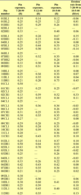
۲- استفاده از پین های فرسایشی : اگر هدف شما تغییرات کوچک کناره رودخانه است  ، میتوانید از پین های فرسایشی استفاده کنید . این پین ها ۱۶/۱ تا ۸/۱ اینچ قطر و ۴ تا ۱۲ اینچ طول دارند و جنس آنها فلزی است . پین ها را  به  طور افقی  و در  فواصل معین در کناره های رودخانه میکوبند . به طوری که مقدار معینی از آنها بیرون باشد .سپس ارتفاع هر پین را با خط کش و ...اندازه گیری میکنند . با بازدید پی در پی این پین ها ، اندازه ای که پین از خاک کناره بیرون آمده

اندازه گیری  می کنند . اگر  پینی در جای خود وجود نداشت ( ممکن است بر اثر جریان آب پین کنده شود ) در  همان ارتفاع ، پین دیگری میکارند .


نمونه ای از گزارشتان اندازه گیری فرسایش کناری رودخانه با استفاده از پین

فرسايش سيلابي يا رودخانه اي

فرسايش سيلابي يا رودخانه اي

فرسايش كناري يا رودخانه اي معمولاً در ديواره هاي آبراهه ها و رودخانه ها مخصوصاً در محل اتصال آبراهه ها و پيچان رود ها زياد  مي باشد در قسمت هاي خارجي خميدگي پيچان رود ها به علت اينكه نيروي برشي آب زياد  است، فرسايش كناري بيشتر است. در اين فرسايش جريان آب به ويژه آب هاي گل آلود حامل شن و ريگ و.... موجب شسته شدن اطراف مسيل و حمل مواد بيشتر با خود مي گردد با اين عمل ديواره هاي بستر استحكام و قدرت خود را از دست داده، و به تدريج در مواقع جاري شدن سيلاب هاي شديد حتي به طور ناگهاني ريزش مي كند و امكان دارد موجب تخريب و ويراني مزارع و روستا هايي شود كه در جوار اين سيلاب ها واقع شده اند. فرسايش رودخانه اي به سرعت جريان آب، تلاطم جريان، قطر ذرات خاك، قدرت چسبندگي و وزن مخصوص ذرات، چگونگي پراكنش ذرات خاك در آب، درجه زبري بستر رودخانه و موانع موجود در مسير جريان بستگي دارد. در اين فرسايش بيشتر مواد ديواره كناره رودخانه و يا بستر كنده مي شود. در حوزه ي مورد مطالعه در تمام طول مسيل اصلي فرسايش كناري مشاهده مي گردد كه داراي شدت و ضعف مي باشد.
فرسايش رودخانه اي


اثر چرخش زمین بر فرسایش کناری رودخانه

شاید جالب باشد که بدانید چرخش زمین به دور خود ، علاوه بر اینکه باعث تغییرات

اقلیمی میگردد ، بر فرسایش کناری رودخانه نیز تاثیر قابل ملاحظه ای میگذارد.

در سال ۱۸۶۰ دانشمندی به نام بار (Baer) برخی تغییرات مورفولوژِیکی رودخانه های

 بزرگ را توجیه نمود.قانون او به نام قانون بار شهرت دارد .

بر اساس این قانون آب جاری که از استوا به سمت قطب ها در حرکت است به

کناره شرقی رودخانه فشار بیشتری وارد میکند.و آبهای جاری که ازقطب ها به

سمت استوا جریان دارند به کناره غربی فشار بیشتری وارد میاورند.برای رودخانه ها

 در نیمکره شمالی که به سمت شمال جریان دارند ، کناره شرقی ،همان قسمت

راست رودخانه میباشد.در حالی که برای رودخانه هایی که در جهت جنوب جریان

دارند ، کناره غربی قسمت راست رودخانه است.

این دانشمند برای ثابت کردن نظریه خود تعداد زیادی رودخانه مانند  

رودخانه های  راین،می سی سی پی و نیل را مورد بررسی قرار داد.برای مثال:

 .در رودخانه ولگا(Volga) در روسیه  کناره راست رودخانه به کناره تپه ای(Hill bank)

و کناره چپ ،کناره چمنزار (Meadow bank) نامیده میشود.کناره راست در این

رودخانه  همواره در معرض فرسایش قرار دارد و فرسایش منجر به نشست

 توده های سنگ و خاک در این کناره میگردد.

               منبع:River morphology   

               Mangel sdorm,Toachim                       

                                          1990      

منبع : http://www.abkhiz.blogfa.com/

چند مقاله در مورد فرسایش کناری

What causes bank erosion?

Inner-Bank Erosion Processes and Solutions at Coastal Inlets

 COASTAL INLET BANK EROSION

Nature of bank erosion along the Brahmaputra river channel

Mississippi River Bank Erosion & Boating

Quantifying River Bank Erosion with Scanning Laser Altimetry David

Bank erosion and protection on the Brahmaputra (Jamuna) River

Bank Erosion = فرسایش کناری

Bank Erosion

The stream is severely eroded along its course through the Melville Koppies nature reserve (east and west). The reach downstream of the point where the east catchment stream joins the main stream is particularly badly eroded, having vertical banks up to 3 m high. This makes it difficult to approach the water?s edge and in places the bank represents a danger to users of the nature reserve, because it has been undercut and is susceptible to collapse.

The flood attenuation measures discussed in section 2.4.3 would certainly reduce erosion of the stream banks. Flood attenuation is, however, generally expensive and requires large open spaces. An alternative to reducing the stream bank erosion is to provide physical protection to the stream banks.

It should be noted that the two methods of reducing erosion (flood attenuation and bank protection) are not exclusive and a combination of the two may produce an economical and environmentally satisfactory solution.

Various methods of stream bank protection are available, most of which involve the re-construction of the bank with gabions or inter-locking precast concrete blocks, such as Envirowall, L?lstein or Armorflex. All of these methods create an environmentally "hard" look and do not retain the natural look of the stream. They are also fairly expensive.

A less formal, more environmentally 'soft' and cheaper solution would be the use of gum poles or brushwood wickets to protect the stream banks at points where trees are threatened or the bank is dangerously undercut.

Gum Pole Barrier

The use of gum poles entails the placing of a barrier against the eroded section of the stream bank. The gum poles are sharpened at one end and driven into the ground side by side.  To secure the top of the barrier a horizontal pole is placed against the barrier approximately two thirds of the way up and pulled tight against the barrier with the aid of "Duckbills" (See Appendix 6.1), anchored in the bank at regular intervals. Figure 3.1 is a sketch of a typical panel.

The use of 100 mm gum poles is recommended as this would lend itself to sharpening of the points and driving into the ground with the use of a sledge hammer, while still providing adequate strength. It is recommended that a geotextile (Bidim (see Appendix 6.2) or a similar product) be placed between the stream bank and the barrier.

This is necessary to prevent scouring of the stream bank by water flowing through the small gaps between the poles. These gaps are due to the irregular nature of the poles and are unavoidable.

At the beginning and end of the protected section of the bank some sort of arrangement would be necessary to prevent water flowing in behind the barrier and eroding the bank. Extending the barrier at an angle into the bank for about 1-m at the edges of the barrier should solve this problem.

The advantages of this method of erosion protection are that no specialised machinery or trained construction team is required. The work could be done with unskilled labour and only requires a saw to cut points onto the gum poles and a sledgehammer to drive the poles and the duckbills into the ground.

The estimated cost of this form of protection is R1 10/m2.

Brushwood Wickets

Brushwood wickets have been used successfully for stream bank protection elsewhere in the world

1. As can be seen from the photograph in figure 3.2, they are environmentally and aesthetically soft and can be constructed by manual labour. Used in conjunction with large, loose boulders they would provide an appropriate solution to the erosion problem here. The major disadvantage is that regular maintenance would be necessary.

Other variations of this technique, such as weaving laths through gum poles driven at about 1,0-m spacing can also be used. The estimated cost is between R50/m2 and R100/m2.