|
Rain
Rain is undoubtedly the largest cause of erosion. Water is about 800 times heavier than air, half to one third the weight of rock and about equal in weight to loose topsoil. When it flows, it can move loose substances with ease. Surprisingly, rain's most damaging moment is when a water drop hits the ground. |
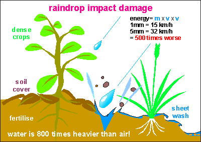 This diagram shows the effect of raindrop impact. Only recently its unexpected destructive power has been discovered. Previously it was thought that sheetwash, the flow of water over the soil, was the most destructive. The kinetic energy of a moving object is equal to half its mass multiplied by its speed squared: e=mv2/2. As water droplets grow in size, both their speed and mass increase. The mass of a 5 mm raindrop is 5x5x5=125 times that of a 1 mm drop and its 'terminal' speed doubles, resulting in a destructive energy 500 times larger! Thus the destructive power of rain increases dramatically as the rainstorm produces larger drops, which is relatively rare. But when it occurs, its effect is profoundly destructive. In the past ten years, starting around 1987, rains have become heavier everywhere in the world, and with it, erosion from raindrop impact.
To fight this kind of erosion, it is only necessary to keep the soil covered, either by dense foliage or by a ground mulch. Hence the importance of growing a cover crop under horticulture (fruits, wine), keeping the soil covered after harvesting (stubble on the field), and not overgrazing pastures. On building sites, a mulch should be spread or a plastic cover, or a temporary grass cover. Road sides should at all times be vegetated and not mowed to show the dirt. Fertilisation helps to make foliage denser and to produce more leaf litter. Everyone could play a role here.
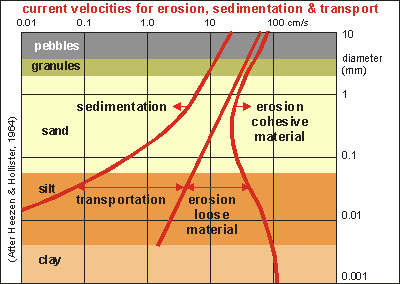 As rain drops hit the soil, they loosen its structure, freeing up fine clay particles, which do not settle down easily, and which are transported down-hill in the sheetwash. The diagram on right shows how this happens [1]. It is a very important diagram, since it shows how particles are transported, and it applies to wind, dunes, beaches, coasts, rivers and estuaries. It has to do with the friction a particle experiences when moving through a medium (water, air). The scientist Stokes formulated this mathematically, and it is shown in the three red curves. The left one gives the speed at which particles settle out; the rightmost one the speed to erode cohesive material; the middle one to erode loose material.
Horizontally: the water speed from 0.01cm/s to 1000cm/s (36 km/hr or 20 knots). Vertically the grain size from 1 micron (clay) to 10mm (pebbles). The coloured bands show where clay becomes silt, then sand, then granules, and pebbles.
Look at pebbles first (top grey band) and assume they form a loose river bed. Nothing happens till the speed exceeds 20cm/s. Even then the pebbles won't move. It needs a water speed of close to 100cm/s (2 knot) to start moving the bed. Once pebbles are on the move, they won't settle out until the speed has decreased below 20cm/s. This transportation gap between erosion and sedimentation, widens as the particles become smaller. Thus silt and clay particles reluctantly settle out. It takes clay weeks in fresh water.
The right-hand curve shows how cohesive material erodes. Sand and gravel do not pack very well and even cohesive sand or pebbles, are easily eroded. But the situation changes for silt and clay. Once packed, they need as much water velocity as a packed bed of pebbles! It explains how easily clay can suffocate water organisms and how a packed cake of clay stays put for years. (For instance, the 7 cm clay bed deposited in 15m deep water by cyclone Bola, took 7 years to disappear.) It also explains how rain drops (see previous subchapter) have practically no effect, until their energy becomes sufficient to erode the packed silt and clay. It is a very sudden transition, explaining why soil erosion happens only rarely, but when it happens, it does so in grand style. Another steep effect is that water, laden with soil, becomes up to twice as heavy, exerting more pressure and scouring more readily. It is as if all three red curves are moved to the left by a factor of two. Being heavier, water also flows more rapidly down-hill, causing even more destruction. Its erosive energy mv2 can increase up to 8 times! In addition, both its pressure and friction increase, making it even more effective at scouring river banks.
Using this knowledge, one can understand that particles settle out in different places, as a river slows down in its lower reaches. Follow the leftmost curve: first the pebbles; further down clean sand and perhaps near the sea the silt. But the clay travels all the way to the sea. Here something else happens.
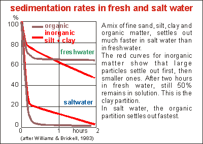 A simple but very important experiment has shown that in salt water fine particles and organic matter settle out considerably faster than in fresh water (4-200 times, depending on particle size). It is thought that the salt water encourages particles to join together, thus making them larger and sinking faster, but this goes against Bernouilli's law and the sedimentation/transport diagram above. [2]
Reader please note, that no scientific work has been done to explain this phenomenon. Water is an excellent solvent for charged particles due to its polarity and charged ions OH- and H+. Salt consisting of Na+ and Cl- may neutralise much of water's capacity to dissolve substances.
Its effect is that fine silt and clay settle out, as soon as they reach salt water, which happens in coastal estuaries. Organic matter does the same, enriching mud flats and mangroves.
This effect may also explain why mud from rivers is so detrimental to the coastal marine environment. Clay settles out very quickly, forming crusts on top of everything, suffocating organisms, while being difficult to remove.
Water causes the following types of erosion:
- raindrop: rain drops hit bare soil and detach it. Fine particles stay suspended and wash down-hill. The clay portion of the soil, which binds nutrients, is lost and with it the nutrients as well. Modest rains cause dirty rivers, affecting water creatures. Remedy: keep the soil covered by foliage, stubble and mulch on cropland, mulch on bare building sites, trees over grassland.
- sheetwash: water moves over the ground, detaching fine particles. Remedy as above.
- rilling: a problem which is typical of worked and ploughed soil. Water forms small gutters (rills) that transport much soil. Once water starts to form rills, erosion is very high and soil particles are moved off the field entirely. As water moves down hill, it meets up with more water, running ever stronger and gouging ever deeper and transporting ever more soil. The remedies are found in conservation tilling and contouring. As cropland ages, it becomes more sensitive to compaction and waterlogging, resulting in more runoff, which causes this problem.
- gullying: water moves through creeks, widening and deepening these into gullies, baring the rock and transporting ever more soil to the sea. When attempting to protect water courses, one must keep in mind that obstructed water causes flooding. So gullies in steep terrain require the water to be slowed down. Where rivers flow slowly, no obstacles must be placed in their way, like trees on river banks. Gullies can be filled with logs and planted with vegetation like lilies, and check dams can be erected across gullies.
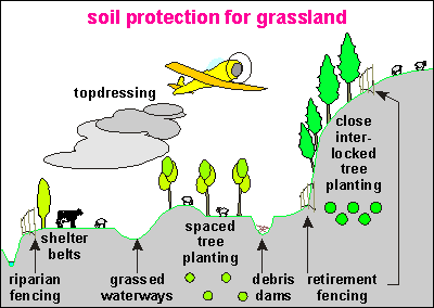
This diagram shows the various remedies to combat erosion on grassland and hilly terrain. From left to right:
- riparian fencing: by fencing waterways, cattle won't trample river banks and natural vegetation can regrow. Also tree planting on river sides helps. Make sure the flat land is not part of the river's flood zone.
- shelter belts: shelter belts provide roots at the boundaries of the field, sheltering the soil, supplying organic matter.
- grassed waterways: a very effective protection of shallow water ways is to grass them over. Grass leaves bend over in the current, protecting the soil. Note that grass needs sunlight, so shelter belts must be placed on the correct side. Make grassed waterways wide and shallow to slow the water down and to prevent it from rilling and then gullying the waterway. Avoid spraying and mow regularly. Avoid length-wise tyre tracks.
- spaced tree planting: trees provide deep roots that hold the soil; cycle deep nutrients and lost nutrients, provide organic matter and more. Trees must compete with highly metabolising grassland, thus should be fast growing and deciduous.
- debris dams: debris dams check the water in steep gullies. They should not be used in slow-flowing waterways. Any kind of debris would do but natural products such as tree stumps, branches, plantings are better.
- retirement fencing: problem areas should be fenced for retirement so that seedlings are no longer grazed. Fencing is an absolute must to encourage natural growth and to protect tree plantings.
- close tree planting: on retired land, trees can be planted closely. Once retired, any kind of tree can be planted, as necessary for forestry or for slow growing native bush.
- topdressing: fertilising is the best remedy against erosion, both immediately and in the long term.
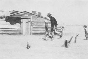 Memories don't last forever. They disappear when one dies, reason why people are doomed to repeat the mistakes of their grandparents (3 generations = about 90 years). How many people today would remember the days of the dust bowl? This famous photograph in all its sadness, reminds us of an event in the history of agriculture in America, that is remembered for its unavoidability and its sadness. A farmer and his two sons are seeking shelter from the arriving dust storm. A derelict shed speaks of extreme hardship. Nothing on their land is like it was only a few years before.
 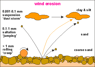 Just like moving water being able to move soil, moving air can do so too. In fact in the same way as the curves of the erosion/sedimentation diagram above (soil51.gif). Fine particles are moved easily (but not when wet) and when they are as small as clay and silt, they become airborne, reluctant to settle out again, even though air is 800 times lighter than water. Sand particles between 0.1 and 1 mm move by saltating (jumping) over the ground, like a sheet. Heavier particles move by rolling.
  To avoid wind-blown erosion, arid soils should not be worked, but in order to survive, people do. The remains of the previous crop (stubble, stalks, straw) should not be removed until just prior to planting. Strip cropping shelters the land and so do shelterbelts. Reduced tillage or no-tillage is preferable. Once the soil has been swept into land dunes (as opposed to sea dunes), these should be planted and stabilised. Fertiliser is an important weapon in doing so.
 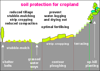 Remedies for saving cropland are, from left to right:
 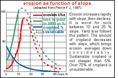 Because of the enormous variability in field data, soil losses are difficult to quantify. The graph on the right shows how crop land erosion increases with slope. Flat land is very stable (losing 2-5 times natural replenishment!) but soil losses increase rapidly with land sloping 2-5%. Land with a 10% slope has 8 times higher erosion, which makes it impossible to farm by ploughing, but perennial crops may be sustainable. At 15% slope, soil erosion has doubled again. But slopes over 20% appear to be less affected, and the reasons for this could be that they are higher uphill, less prone to receive the water from a field higher up, and the run from hillcrest to valley floor is shorter. Their fields are shorter too.